Bangor Garth Pier into Menai Strait toward Anglesey, North Wales, UK

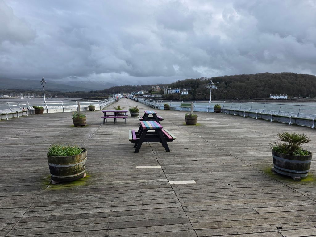
Bangor Garth Pier is a Grade II* listed Victorian landmark in North Wales, recognized as the second-longest pier in Wales and the ninth-longest in the British Isles. Stretching 1,500 feet (460m) into the Menai Strait, it is celebrated for its well-preserved architectural elegance and panoramic views of the Eryri (Snowdonia) mountains and Anglesey. 

Bangor Pier taken 15th March, 2026

Key Highlights

  • Award-Winning Heritage: It was named Pier of the Year 2022 by the National Piers Society for its successful community-led restoration and original Victorian charm.
  • Victorian Kiosks: The deck features a series of distinctive octagonal, onion-domed kiosks that house local independent businesses, including sweet shops, artisan crafts, and a gallery.
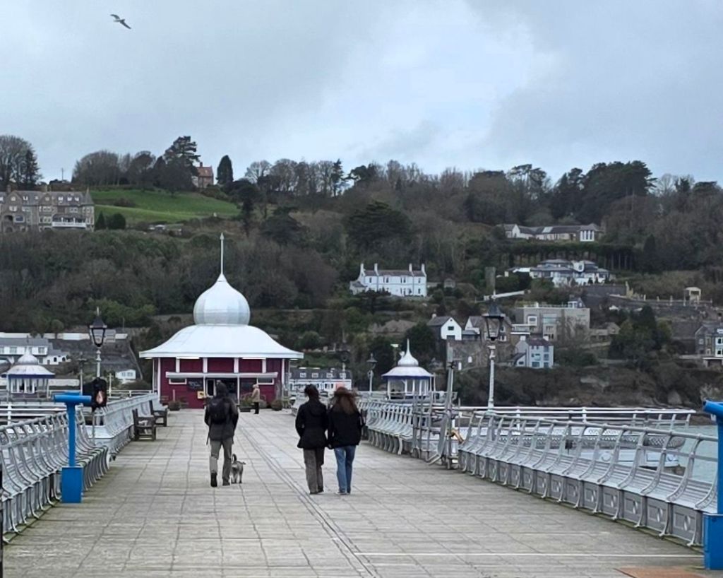
  • The Pavilion: At the pier-head stands a large domed pavilion housing a family-friendly café famous for its tea, coffee, and homemade scones.
  • Leisure & Wildlife: The pier is a popular spot for crabbing and fishing. Visitors can also spot local wildlife, including a colony of black guillemots often referred to as “Bangor Penguins”.

Bangor’s Garth Pier is a Grade II* listed structure stretching 1,500 feet (460m) into the Menai Strait toward Anglesey. It is the second-longest pier in Wales and is renowned for its well-preserved Victorian architecture, featuring original kiosks and ornamental ironwork. Unlike many other piers, it was never heavily modified with large theatres, retaining its elegant, traditional character. 

Bangor Pier, March 2026

Comprehensive Historical Timeline

The Early Origins (Pre-1896)

  • 1292: Records mention the Porthesgob ferry operated by the Bishop of Bangor, establishing the area as a key crossing point to Anglesey.
  • 1826: The principal crossing shifted to the new Menai Bridge, though the local Garth ferry continued operating for many years.
  • 1893: A Parliamentary Bill was passed to authorize the construction of a permanent pier. 

The Victorian Boom (1896–1914)

  • 1896 (May 14): Lord Penrhyn officially opened the pier. It was designed by JJ Webster and cost approximately £17,000.
  • 1896–1914: The pier thrived as a landing stage for pleasure steamers from Liverpool, Blackpool, and the Isle of Man. A 3-foot gauge tramway ran its length to transport passenger luggage.
  • 1914: The cargo ship SS Christiana broke free and crashed into the pier, severing a section of the structure. The baggage railway was subsequently removed. 

Transition & Decline (1915–1971)

  • 1921: Permanent repairs for the 1914 ship damage finally resumed following the conclusion of World War I.
  • 1927: Professor Phillip White established a small marine laboratory in one of the pier kiosks, eventually leading to Bangor University’s renowned marine science department.
  • 1939–1945: The pier remained a local landmark through WWII; historical photos show servicemen and locals using the structure.
  • 1960s: Lack of investment led to severe structural deterioration.
  • 1971: The pier was officially closed to the public on safety grounds. 

Threat of Demolition & Rescue (1974–1988) 

  • 1974: Ownership passed to Arfon Borough Council, which proposed demolishing the structure.
  • 1975–1978: Following public outcry, Bangor City Council purchased the pier for a symbolic fee of 1p.
  • 1982: A major six-year restoration project began, funded by the National Heritage Memorial Fund and the Manpower Services Commission.
  • 1983: The ongoing project won the Prince of Wales Award.
  • 1988 (May 7): The Marquess of Anglesey officially reopened the pier after a £3 million restoration. 

The Modern Era (2011–Present)

  • 2011: Surveys revealed new structural issues, specifically with the sub-structure.
  • 2017: A new £1 million restoration programme commenced to strengthen the structure and replace handrails.
  • 2021: The pier celebrated its 125th anniversary, and the Friends of Bangor Garth Pier volunteer group took over a kiosk to support further fundraising.
  • 2022: The National Piers Society named it Pier of the Year.
  • 2024: The pier head shelter, absent since 2018, began reconstruction in-situ.
  • 2026: The city plans to hold major celebrations for the pier’s 130th anniversary

Bangor Garth Pier into Menai Strait toward Anglesey, North Wales, UK

Llandudno Town Map, North Wales, UK, 15th March 2026

Llandudno Town Map, North Wales, UK

Llandudno overview and detailed annotated timeline history by era and year to 2026

Llandudno, often called the “Queen of the Welsh Watering Places,” is a prominent seaside resort on the Creuddyn Peninsula in North Wales. Planned specifically as a mid-Victorian holiday destination, the town is renowned for its well-preserved 19th-century architecture, sweeping promenade, and the towering limestone headland of the Great Orme

Town Centre, photo taken March 2026

Historical Timeline by Era

Ancient & Medieval (Prehistory – 1800s)

  • Bronze Age (c. 2000 BCE): Extensive copper mining begins on the Great Orme; these are now recognized as the world’s oldest known copper mines.
  • 6th Century: St Tudno establishes a church on the Great Orme, giving the town its name (“Church of Saint Tudno”).
  • 1284: King Edward I conveys the Manor of Gogarth to the Bishop of Bangor.
  • Early 1800s: Kashmiri goats are introduced to the Great Orme, later becoming an iconic symbol of the town. 

The Victorian Transformation (1840 – 1901)

  • 1840: St George’s Church is built to serve the growing village.
  • 1848: Architect Owen Williams presents development plans to Lord Mostyn to turn the marshlands into a resort.
  • 1858: The railway branch line from Llandudno Junction opens, making the resort accessible to wealthy tourists from Liverpool and Manchester.
  • 1862: The Great Orme Lighthouse is built by the Mersey Docks and Harbour Board.
  • 1877/1878: The Llandudno Pier opens (700 metres long) and the Marine Drive carriage road around the Great Orme is completed.
  • 1887: Happy Valley is gifted to the town by Lord Mostyn for Queen Victoria’s Golden Jubilee.
  • 1890s: A large Jewish community settles in Llandudno, escaping persecution in Eastern Europe. 

Modern & Contemporary (1902 – 2026)

  • 1902: The Great Orme Tramway—the UK’s only cable-operated street tramway—opens.
  • 1914–1918 (WWI): Hotels are converted into hospitals; the 1st (North Wales) Brigade is headquartered here.
  • 1940–1945 (WWII): The town hosts the Coast Artillery School and becomes a haven for those escaping the London Blitz.
  • 1956: The electric tramway service to Colwyn Bay closes.
  • 1963: The Beatles perform in Llandudno; the Welsh National Eisteddfod is held in Happy Valley.
  • 1986: The first Llandudno Victorian Extravaganza is held to celebrate the town’s heritage.
  • 1994/2006: The North Wales Theatre opens, later expanded and renamed Venue Cymru.
  • 2017: A new lifeboat station is completed on the North Shore.
  • 2022: Llandudno officially twins with Champéry, Switzerland.
  • 2023–2026: Venue Cymru becomes the permanent home for the Welsh Open snooker tournament (February).
  • 2026 (Scheduled):
    • February: Nick Beer 10K (Feb 15) and Welsh Open Snooker (Feb 23–Mar 1).
    • May: Victorian Extravaganza and Transport Festival (May 2–4).
    • June: Llandudno Triathlon & Duathlon (Jun 28).
Wetherspoon pub reopens on 22nd August 2001 – photo as of March 2026

The Palladium in Llandudno, a Grade II listed building, was transformed into a JD Wetherspoon pub in 2001. The following timeline outlines its history from its origins as a grand theatre to its current use. 

The Palladium Timeline

  • 1920: The Palladium Theatre opens on the site of the former 1894 Market Hall. Designed by Arthur Hewitt, it originally featured 1,500 seats across three levels: stalls, dress circle, and balcony.
  • 1972: The building is subdivided for multi-purpose use. Bingo is introduced in the former stalls area, while a 600-seat cinema occupies the circle area.
  • 1999: The venue, then owned by Apollo Leisure, officially closes on 8th September.
  • 2000: The building is purchased by JD Wetherspoon for conversion into a pub.
  • 2001: Following a restoration project that returns the auditorium to a single open space, the Wetherspoon pub reopens on 22nd August – see picture above taken March 2026.
  • 2012–2013: A significant restoration of the exterior is completed to maintain the building’s historic facade.
  • 2024–2025: Wetherspoon invests approximately £1 million in a major refurbishment, focusing on the preservation and restoration of the heritage ceiling and the proscenium arch. 

Visiting The Palladium

  • Location: Gloddaeth St, Llandudno LL30 2DD
  • Type: Wetherspoon Pub in a converted Grade II listed theatre.
  • Features: Retains original theatrical character including painted ceilings, balcony details, and original seating.
  • Hours: Generally open from 8:00 am daily, closing at midnight or 1:00 am on weekends. 

Bolton Town, Greater Manchester, UK – Timeline History

Bolton’s evolution from a small moorland settlement to a world-leading industrial powerhouse and modern metropolitan borough is marked by these key milestones:

Early History & Foundations

Civil War & Growth (17th–18th Century) 

Industrial Revolution (19th Century)

  • 1828: The Bolton and Leigh Railway opens, becoming the oldest in Lancashire.
  • 1838: Bolton is incorporated as a municipal borough.
  • 1839: Chartist riots lead to the reading of the Riot Act.
  • 1873: The current Bolton Town Hall is officially opened.
  • 1889: Bolton is granted County Borough status, making it self-governing and independent of Lancashire County Council. 

Modern Era (20th Century–Present)

Bolton Town, Technical Timeline History

Bolton’s technical and industrial evolution shifted it from a medieval market town to a global leader in cotton spinning and engineering, before transitioning into a modern educational and service hub. 

Industrial Revolution & Engineering (1700s – 1800s)

Bolton’s transformation was driven by local inventors whose technical breakthroughs redefined the textile industry. 

  • 1779: Samuel Crompton invented the Spinning Mule at Hall i’ th’ Wood, combining earlier technologies to produce high-quality yarn.
  • 1780: The town’s first spinning mill opened, marking the start of large-scale mechanised production.
  • 1820: Thomas Bonsor Crompton patented a method for continuously drying paper, a major technical breakthrough for the local paper industry.
  • 1828: One of the world’s first railways, the Bolton and Leigh Railway, opened using George Stephenson’s locomotive “The Witch”.
  • 1873: The Bolton Town Hall opened, a massive Victorian architectural project reflecting the town’s industrial wealth. 

Modern Infrastructure & Power (1880 – 1950)

Technical focus shifted toward municipal services, electricity, and the zenith of the cotton industry. 

  • 1880: Horse-drawn municipal transport began, followed by a telephone connection between Bolton and Manchester.
  • 1894: The first electric power station opened at Spa Road on October 31st.
  • 1899: The town launched its first electric tram service.
  • 1914: The Back o’ th’ Bank electricity generating station began supplying the town.
  • 1929: Bolton reached its industrial peak with 216 cotton mills in operation. 

Education & Re-development (1960s – Present)

As the cotton industry declined, Bolton pivoted toward technical education and retail-led regeneration. 

  • 1963: The Bolton Technical College split into Bolton Technical College and the Bolton Institute of Technology (the precursor to the University of Bolton).
  • 1971: The Crompton Place Shopping Centre opened as part of modern town-centre re-development.
  • 1980s: Cotton manufacturing virtually ceased, and the town’s industrial structure diversified into general engineering.
  • 2026: Planning is underway for the demolition of Crompton Place to create a new pedestrian link and modern mixed-use development, scheduled for 2027. 

Bolton Town, Greater Manchester, UK – Timeline History

Salford Quays, Salford, Greater Manchester, UK

Salford Quays has evolved from a largely empty landscape of racecourses and medieval halls into one of the UK’s most significant urban regeneration projects.

1. The Industrial Era (1887–1981)

2. Decline and Early Redevelopment (1982–1999) 

3. Cultural and Digital Expansion (2000–Present)

  • 2000: The Lowry arts centre is opened by Queen Elizabeth II.
  • 2001: The Lowry Outlet Mall (now Quayside MediaCity) opens to the public.
  • 2002: The Imperial War Museum North opens its doors across the water from The Lowry.
  • 2007–10: Construction of MediaCityUK takes place; the BBC confirms the relocation of five departments to the site.
  • 2011–12: BBC and University of Salford staff move into MediaCityUK; ITV later moves its Manchester base (including Coronation Street) here in 2013.
  • 2021: Buildings at MediaCityUK achieve net zero carbon status.
  • 2022: The Salford Quays 2030 vision is launched to further enhance the area as a vibrant community hub. 

Salford Quays, Salford, Greater Manchester, UK

My MediaCityUK Salford Quays photo timeline

Salford Quays Technical Timeline

From its engineering origins as the Manchester Docks to its current status as a digital hub, 

Salford Quays has undergone a massive technical and structural transformation. 

Industrial Foundation & Engineering (1887–1982)

  • 1887–1893: Construction of the Manchester Ship Canal, an engineering feat measuring 35.5 miles from Eastham to Manchester.
  • 1894: Official opening of the Manchester Docks by Queen Victoria, establishing Manchester as Britain’s third-largest port.
  • 1905: Opening of No. 9 Dock, the largest in Salford, by King Edward VII.
  • 1970s: Deindustrialisation begins as the rise of containerisation makes the narrow canal obsolete for modern, larger ships.
  • 1982: Final closure of the docks, resulting in 3,000 job losses and leaving the area as a polluted wasteland.

Regeneration & Environmental Recovery (1983–2000) 

  • 1983–1984: Salford City Council acquires the derelict docks.
  • 1985: Launch of the Salford Quays Development Plan, envisioning a new residential and commercial district.
  • 1986–1990: Massive infrastructure programme: polluted dock water is separated by bunds, and a compressed air mixing system (Helixor) is installed to improve water quality.
  • 1987: Introduction of 12,000 coarse fish to the now-cleaned waterways.
  • 1989: Opening of the Mariners Canal to link the Ontario and Erie Basins.
  • 1999: Completion of major bridge works and the Metrolink extension, connecting the Quays to Manchester city centre.

Cultural & Digital Expansion (2000–Present)

  • 2000: The Lowry arts centre officially opens.
  • 2002: Completion of the Imperial War Museum North, designed by architect Daniel Libeskind.
  • 2007: Construction begins on MediaCityUK.
  • 2011: The BBC completes its move to three buildings (Bridge, Dock, and Quay House).
  • 2014: Coronation Street begins filming at its new dedicated production centre in MediaCity.
  • 2021: MediaCityUK buildings become the first in the UK to achieve net zero carbon status.
  • 2025–2030 Vision: Ongoing regeneration frameworks aim to deliver over 3,000 new homes and 75,000 sq metres of commercial space. 

Park High Secondary School, Park Road, Hindley, Wigan, Lancashire, UK. WN2 3RY

1980 to 1985 : Park High Secondary School
Park Road, Hindley, Wigan, Lancashire, UK. WN2 3RY
(formerly Hindley and Abram Grammar School now PDC)

8 GCE ‘O’ Levels – mark whitfield
All grades ‘C’ and above including Computer Studies, Maths and English

Class photos: first year (bottom, 2nd from right), fourth year (top, 4th from left)

mark whitfield DSCF0557
Park High Secondary School
Park Road, Hindley, Wigan, Lancashire, UK. WN2 3RY

December 2022 – C&CA UK’s Communications & Engagement Award Winner – Cloud & Custom Applications – Capgemini UK

December 2022 – C&CA UK’s Communications & Engagement Award Winner – Cloud & Custom Applications – Capgemini UK

Dr. Fred Dibnah MBE today, Bolton, UK

Dr. Fred Dibnah MBE today, Bolton, UK

At Trafford Centre, 14/10

At Trafford Centre, 14/10

In December 2022 – C&CA UK’s Communications & Engagement Award Winner – Cloud & Custom Applications – Capgemini UK

December 2022 – C&CA UK’s Communications & Engagement Award Winner – Cloud & Custom Applications – Capgemini UK

At Knowle Farm – Rattery – Near Totnes, Devon 2008

At Knowle Farm – Rattery – Near Totnes, Devon 2008

Knowle Farm set in 44 acres of South Devon countryside offers six beautifully converted barns overlooking wonderful farmland views.
The cottages sleep from two to eight plus cots.

‘Woodbine’ sleeps eight plus cots
‘Moncks Green’ sleeps six plus cot
‘Applecross’ sleeps four plus cot
‘Clematis’ sleeps two plus child or cot
‘Foxglove’ sleeps four plus cot
‘Cow-mumble’ sleeps four plus cot
‘Foxglove’ plus ‘Cow-mumble’ combined to sleep 8 plus cots (click for details)

Knowle Farm is rated Four Stars by ‘VisitBritain’ Quality in Tourism

The standard of each of our cottages is excellent, with simple but tasteful décor and furnishings.
We take a real pride in the condition of our cottages and you can be confident that when you arrive and see your home for your holiday stay you will be absolutely delighted (we are featured in the Good Holiday Cottage Guide for 2008).

We have tried to furnish the cottages with just about everything you will need and all include:
Wood burning stove, automatic washing machine and tumble dryer, electric hob and oven, microwave, fridge/freezer, iron, widescreen colour T.V., VCR & DVD player, CD/Radio, wireless internet access, linen, duvets and a stair gate. A booster seat is provided in each cottage and high chairs and cots are available on request (please ask when booking). Some cottages have a dishwasher also (see cottage descriptions). Guests should bring their own towels and where applicable cot bedding. Towels (for use within the cottage only) may be hired – see booking form.

We regret we are unable to take pets.
So that furnishings etc. are kept fresh for everyone there is no smoking within the cottages and indoor facilities.

Knowle Farm is a member of the Green Tourism Business Scheme

Rattery, Nr. Totnes
South Devon
TQ10 9JY